| animate |
Flag to specify Animation |
Boolean |
true,false |
|
| animationmode |
Animation mode |
Mode type |
time,layer |
time |
| animationrock |
Flag to specify Animation rocking |
Boolean |
true,false |
|
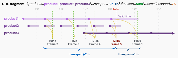
| animationspeed |
Animation speed |
Number |
0-100 |
50 |
| autoprobe |
Flag to control autoprobe of raster pixel values |
Boolean |
true,false |
-1 |
| basemap |
Initial basemap to display |
Basemap ID |
bw,wb,filled,[Components],(Product ID) |
|
| basemaps |
Basemaps to be made available |
(Basemap ID),... |
See basemap list |
|
| bounds |
Initial lat/lon bounds of display |
South,West,North,East |
West negative |
|
| center |
Latitude and longitude to display |
Latitude,Longitude |
West negative |
38,-97 |
| centerproduct |
Product to set center |
Product ID |
|
|
| centervalue |
Value to set center |
ID value |
|
|
| collection |
Initial collection to display |
Collection ID |
See collection list |
|
| databounds |
Lat/lon bounds of the data to load (shape data only) |
South,West,North,East |
West negative |
|
| keyboard |
Flag to control keyboard interaction |
Boolean |
true,false |
-1 |
| labels |
Label to use in display |
Label ID |
line,latlongrid,[Components] |
|
| legend |
Flag to set legend display |
Boolean |
true,false |
1 |
| logo |
Flag to specify logo overlay on large images |
Boolean |
true,false |
1 |
| preloaddata |
Flag to control preload of next frame |
Boolean |
true,false |
-1 |
| products |
Products to display |
(Product ID),... |
|
|
| selector |
Flag to enable/disable Product Selector |
Boolean |
true,false |
1 |
| time |
Anchor time for display and animation |
Y-M-D H:m[:s] |
Absolute time |
|
| timeproduct |
Product to define animation times |
Product ID |
|
|
| timerange |
Time range for animation |
Y-M-D h:m[:s],Y-M-D h:m[:s] |
Absolute time range |
|
| timespan |
Time span relative to anchor for animation period |
#(dhmst)[,#(dhmst)] |
Relative time or time range |
6t |
| timestep |
Time step for animation |
#(dhms) |
Relative time |
1h |
| ui |
Flag to enable/disable the User Interface |
Boolean |
true,false |
1 |
| waitdata |
Flag to control wait for data before next frame |
Boolean |
true,false |
-1 |
| welcome |
Flag to enable/disable Welcome Sheet |
Boolean |
true,false |
1 |
| zoom |
Initial zoom level of display |
Number |
1-20 |
3 |
A
Product ID is the identifier for a given product.
- Product IDs can be found by clicking the info button in the UI, or by checking the product catalog.
- A product ID can optionally contain an exact date and time, formatted as [Product ID]_YYYYMMDD_hhmmss. Full year, month, day, hour, minute, and second are required.
- A product ID can optionally contain an opacity value suffix formatted as [Product ID].opacity. Opacity ranges from 0 (transparent) to 100 (opaque).
- Most API calls support lists of product IDs separated by commas.
Times can be absolute or relative.
- Absolute times are formatted as YYYY-MM-DD hh:mm[:ss]. Full year, month, day, hour, and minute are required; seconds are optional.
- Relative times are formatted as [-]#(dhmst), indicating a (possibly negative) offset from the anchor time. Each of dhmst specifies Days, Hours, Minutes, Seconds, and Timesteps respectively.
- Time ranges are specified as [time start],[time end].
NOTE: Most API calls allow time to be specified using the
time keyword with an arbitrary date and time. The preferred, more efficient way to specify time is to use the
products keyword form
[Product ID]_[YYYYMMDD]_[hhmmss], which requests the exact date and time given without the need to look up the nearest time for each individual request.
- Use the products API to get a list of available times for a given set of products.
- Use the time or latest API to get the nearest available or latest time for a given set of products and nominal time.
See below for examples.